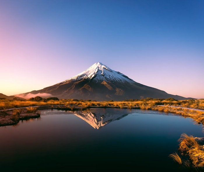
Landscape photography is all about capturing the beauty of the natural world. From majestic mountains to rolling hills, there are endless possibilities for stunning landscape photos. If you’re looking to improve your landscape photography skills, you need to check out this list of the best apps for landscape photographers.
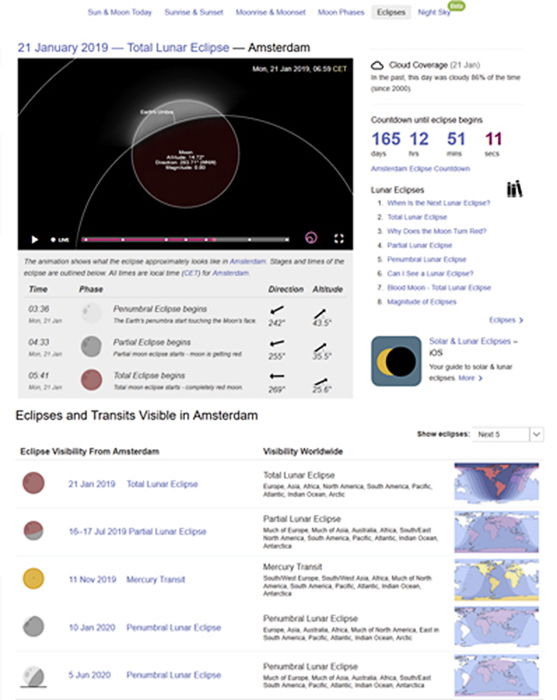
12. Best Apps for Landscape Photographers During an Eclipse: Time and Date
This website has a host of features. I have yet to find any dedicated landscaping app for either Android or iOS that is so feature rich.
Time and Date offers an ephemeris for any place in the world in handy to use calendar tables.
I primarily use this app for planning lunar and solar eclipses many years in advance.
How I Used Time and Date for This Photo
The best time to enjoy a blood moon or indeed any full moon, is after moon-rise, when the moon is close to the horizon. Before moon-set is also a good time.
When the moon is near the horizon, it looks bigger and brighter than when it’s high up in the sky.
This is called the moon illusion and it played a part in the idea behind the Blood Moon shot below.
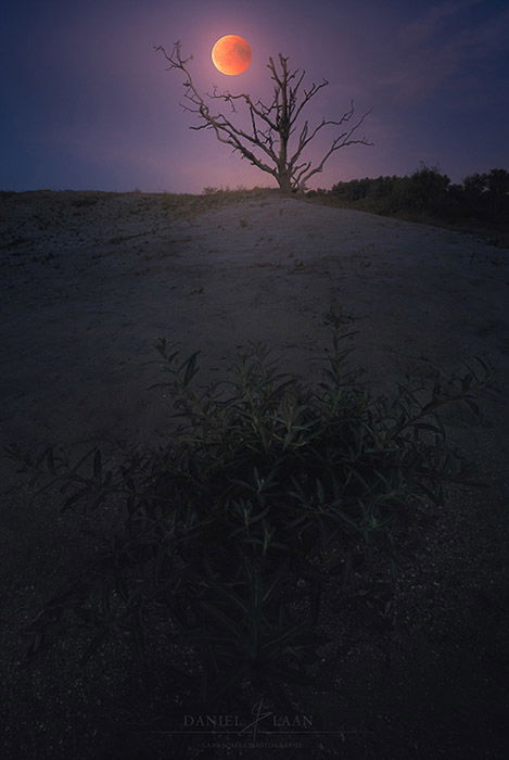
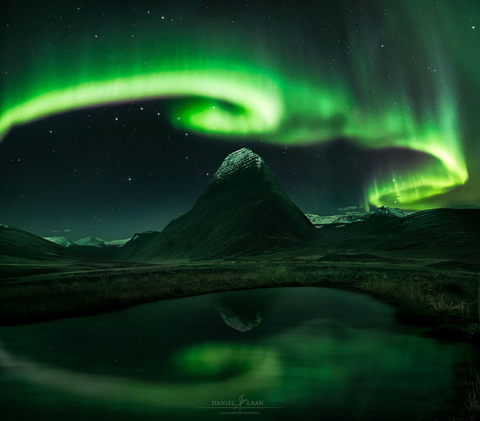
I saw the eclipse path on TimeAndDate.com. That means I knew that the eclipse had already reached totality when the moon rose. And that the fully eclipsed Blood Moon would rise in the east.
So I put myself in a rather familiar area with a clear view of the eastern horizon and a bit of a foreground. But there was a big band of clouds blocking the moon-rise.
TimeAndDate.com gave me the exact time I needed. Between the moment I observed the Moon slide out from the cloud cover at 22:50 and the end of totality at 23:13 local time.
This eclipse might have been the longest in over a century, but I was in quite a hurry.
I ended up taking a wide-angle shot of sea buckthorn for the foreground. Then I combined it with a telephoto shot of the blood Moon to dramatise the end result.
But there was one key part missing in planning this shoot: The exact point on the horizon where the moon would rise. I use another app for Android for exactly this.
11. Best App for the Moon or Sunrise: Sun Surveyor (or PhotoPills)
There’s just one reason why I use Sun Surveyor over PhotoPills. Sun Surveyor was released earlier on Android.
Both photography apps have more or less the same feature set and are available on both iOS and Android now.
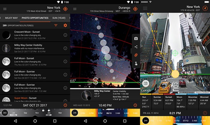
There’s a map with your geographic location and the direction of the sun, moon and even the Milky Way center. But there’s also live-view augmented reality feature.
Live-view in Sun Surveyor shows you an overlay of the path a celestial object follows along the sky.
You can drag the time to the past or future. This means you can see where the sun will rise for instance. That’s fantastic if you want the sun in a very specific area in your photo.
And the Winner Is?
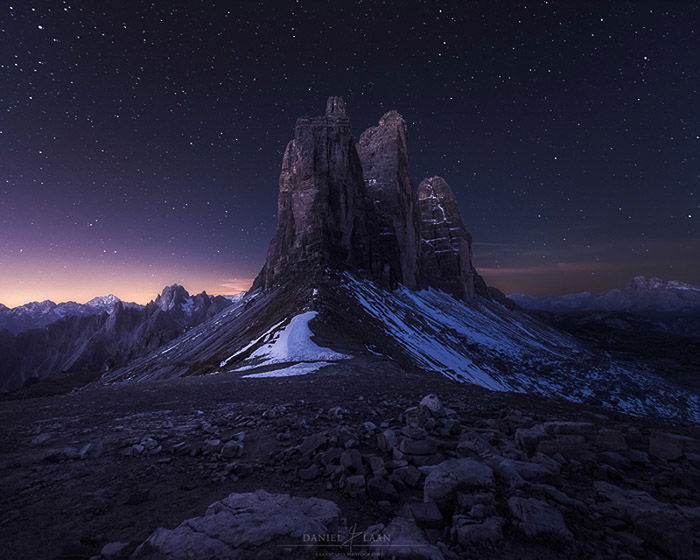
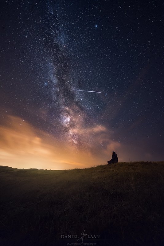
Sun Surveyor is one of the all-around best landscape apps out there. But actually, I find it most useful when planning nightscapes. At my resident latitude, the Milky Way is most visible during very particular dates and specific times during the day.
That has everything to do with the fact that it doesn’t go completely dark in summer here. That’s when the Milky Way center is high in the sky.
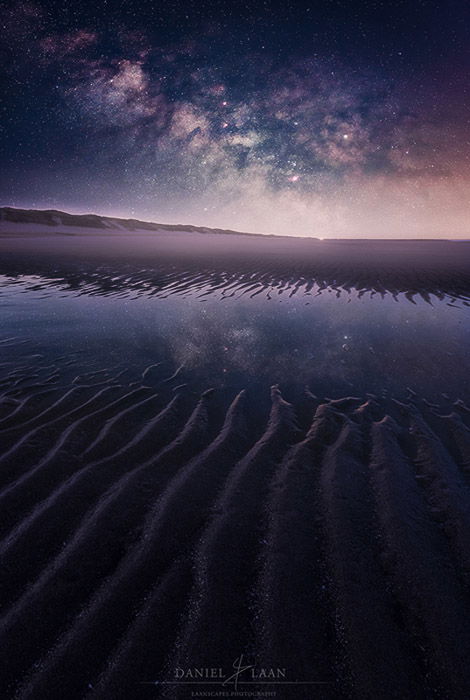
I used Sun Surveyor at the beach for the tracked Milky Way shot below. But I used the app about a year in advance. At any location in the world, you can use Sun Surveyor (and PhotoPills too) to plan ahead of your back country shoots.
Here, I stood in a floodplain at my local beach. I wanted to find out if the Milky Way center would be visible over the length of the Dutch beach.
Two moonless weekends came up through Sun Surveyor. September 3rd 2016 at 11 PM, which turned out to be an overcast night.
On May 27th 2017 at 2:30 AM, I had more luck. I captured the shot below before sunrise on that date.
10. Best App for the Milky Way: Stellarium
PhotoPills and Sun Surveyor are very good general planning apps. But I think the best landscape app for night photography is Stellarium.
There is an iOS version and an Android ap. It’s the open-source desktop application that I will discuss here.
Stellerium started out as an open-source program for PC. With Stellarium, you can see the constellations, the planets, the Moon and the Milky Way. What makes it the best is that there are add-ons.
These plugins enable you to see anything from meteor showers to artificial satellites. That includes the International Space Station.
It is the go-to app for night-sky enthusiasts. It’s also an invaluable addition to your collection of landscape photography apps.
You get a host of options from planning your nightscape photos in advance through the desktop application. And you get the 3D compass in the field when using either of the smartphone apps.
See a bright object and wonder what that is? Stellarium tells you that you’re looking at Jupiter. You can even turn the screen red to save your night vision.
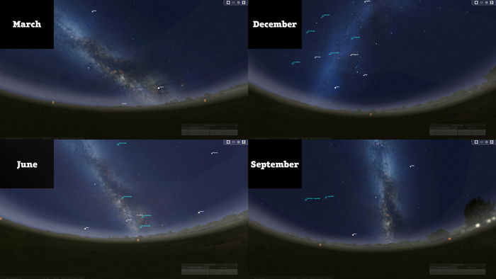
I like how Stellarium illustrates how the view upon the Milky Way changes throughout the seasons.
This helps a great deal when pinpointing those precious few days in more northern latitudes.
9. Best App for Starry Nights: MeteoBlue
The weather is tough to forecast. As a landscape photographer, that’s both frustrating and interesting. Especially when you plan to capture the stars.
There’s a chart that I used to plan nightscapes up to three days in advance. I started that as soon as Stellarium pointed me to a moonless night.
The astronomical seeing chart is not easy to use, but it does provide information I can’t find anywhere else. The air quality for seeing stars and other astronomical objects in the night sky. Or “seeing” for short.
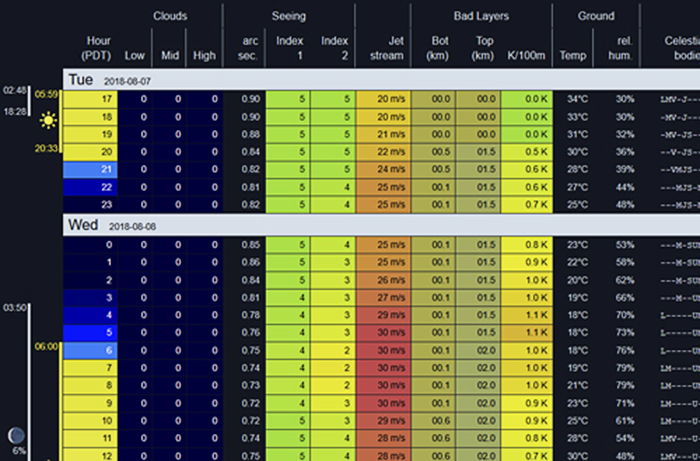
Without making it too complicated: Seeing is an index on a scale that runs from one through five.
Seeing 5 indicates the best conditions. You should be able to see many more stars than when the seeing is at a measly 2.
Again, this chart is location based and works anywhere on Earth. Visit Meteoblue.com and navigate to Special > Astronomical seeing. You’ll see how starry your nights are looking.
8. Best App for Finding the Station: ISS Detector
If you want to further get into niches in landscape photography, I’ve got you covered. I’m guessing you want to know if there’s something interesting to see apart from the Milky Way.
Sure, there are the Orion constellation and the Perseïd meteor shower.
But what if you wanted to do a group photo with a bunch of astronauts at 400 kilometres away?
The International Space Station is orbiting our planet at 17,200 miles per hour. A sighting typically lasts for less than 4 minutes.
The station is also the brightest man-made object in the sky. It is the third brightest object in the sky followed by the Moon and Venus.
Due to light reflecting off the station, it can brighten up to as much as 16 times the brightness of Venus. Reason enough to set up your tripod under cover of darkness.
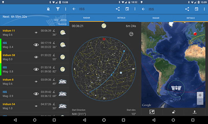
ISS Detector comes with all the necessary forecasting tools. It even has a radar to see where and when the station appears.
But there’s much more orbiting the Earth than the International Space Station.
Find Hubble, the Iridium constellation and even comets. Easy to set up and powerful enough to be used by professionals.
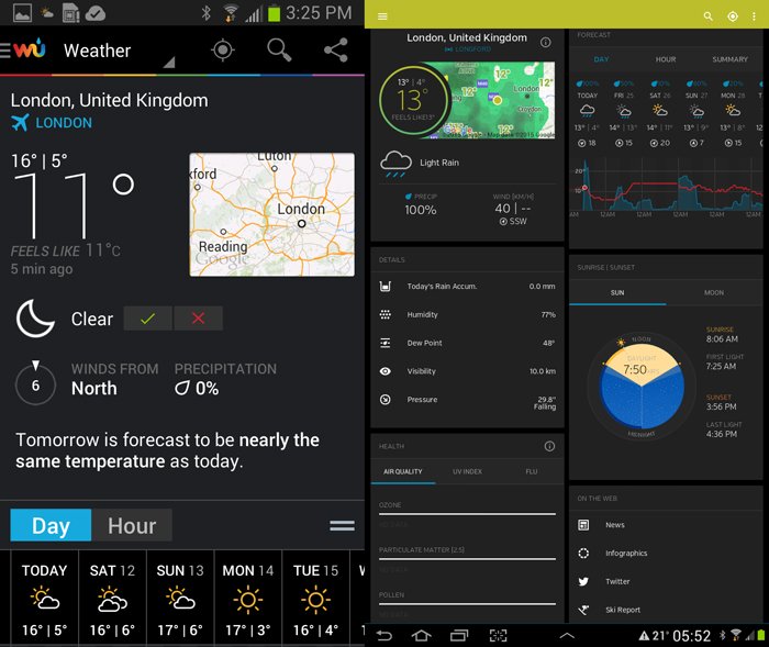
7. Best Weather App: Weather Underground
With Weather Underground, you can build custom forecasts!
It’s based on a number of parameters such as air pressure, relative humidity, temperature, wind speed and location. This way I have a forecast ready for just about every conceivable opportunity.
The “foggy forest” forecast that I set up uses a relative humidity of anything above 90 percent and low wind speeds. It applies to just a particular area that I like to visit in the hours before dawn.
And it works!
Notifications, a clear user interface and dozens of features that you can actually use in planning your landscape photography.
That’s Weather Underground for you.
But there’s another weather service that I like to use. This comes in an altogether featureless website.
6. Best Severe Weather Forecast in Europe: Estofex
This one is for the budding storm chasers among you. Estofex is the acronym for the European Storm Forecast Experiment.
They issue warnings and daily information of severe weather in Europe. Lightning, hail, severe wind gusts and tornadoes for instance.
There are 3 levels of severe (dangerous) weather within 40 kilometres of a point.
A level 1 hazard is a 5% chance of severe weather. At level two, that chance is 15%. Level 3 is also a 15% chance, but for extremely severe weather.
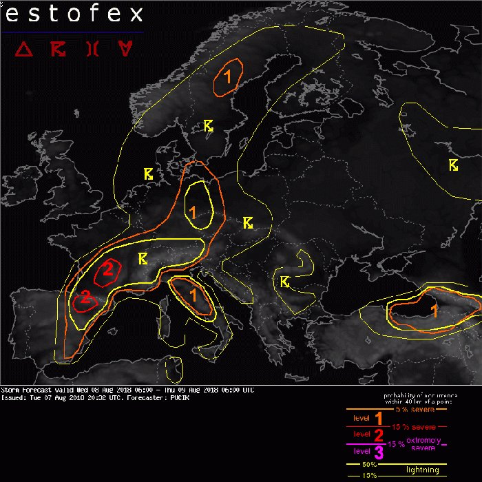
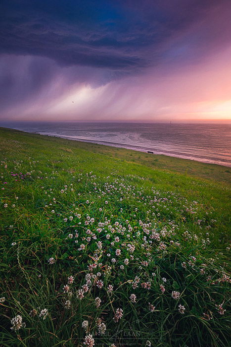
Using Estofex well for photography is a bit of a gamble. Not in the least because the exact location of a beautiful storm can be hard to forecast.
I had many misses when using this service, but also some fantastic cloud formations as a result.
Severe Weather Warnings
The purpose of this website is not to announce landscape photographers an opportunity. Estofex isn’t a landscape photo app. The service warns you for severe weather conditions.
So here’s why I still see it as one of the best landscape apps. Say there’s a level 1 warning within 100 km of my location. Then I’m driving to the area to see if it turns out to be a photogenic storm.
If there’s a level 2, I’m more cautious. I will drive to the edge of that area, but only leave the car if I’m not in an open field waving my tripod around.
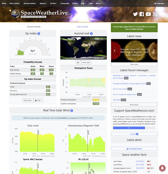
5. Best Northern Lights App: Spaceweatherlive
There’s another type of storm where there are many apps for: Geomagnetic storms. Forecasting the northern lights has never been easier than today.
With so many apps out there that tell you if there’s going to be green in the sky tonight, it’s tough to find the cream of the crop.
I’m not using a native app at all. Instead, I’m going over to SpaceWeatherLive.com for the forecast.
You’ll find 10-day sunspot forecasts and more.
Also, the answer to a simple photography question. “Is the aurora visible right now?”
The northern lights and southern lights are a natural phenomenon.
The aurora occurs because of charged solar particles that interact with the Earth’s magnetic field.
The sun is more active on certain days than on others and as a result, the chances for the aurora can be higher.
There is of course much more to this. But you’ll get a nice looking website with clear answers to your question based on very complicated data.
4. Best App for Navigating Tough Terrain: Viewranger
Viewranger actually got me out of a nasty situation. I came back from a sunset shoot in the mountains and fog started to encroach the mountain I was on.
I was in unfamiliar territory and I couldn’t see three feet in front of me. But I had Viewranger plot my current position on the map.
Smartphones aren’t that accurate to use for hiking in the mountains, but it did the job. Viewranger is a detailed map (anywhere in the world). It lets you navigate the great outdoors.
All this makes Viewranger one of the best landscape apps out there.
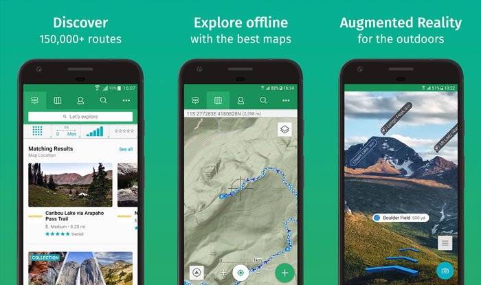
One of the key selling points for me was that these charts work without cell reception. A GPS fix will do. Also included are statistics for tracking your movements. And sharing them with your friends.
It also comes with the capability of loading your GPX data and KML files. You can use these to overlay your planned route.
Best of all: The maps are highly detailed. They’ve been acquired through international collaboration between 23 agencies across the globe.
All 1:25,000 and 1:50,000 scale maps can be obtained through the app, but do cost extra. Don’t let that discourage you.
Viewranger has been around for ages and still gets regular updates. Plus the app itself is free.
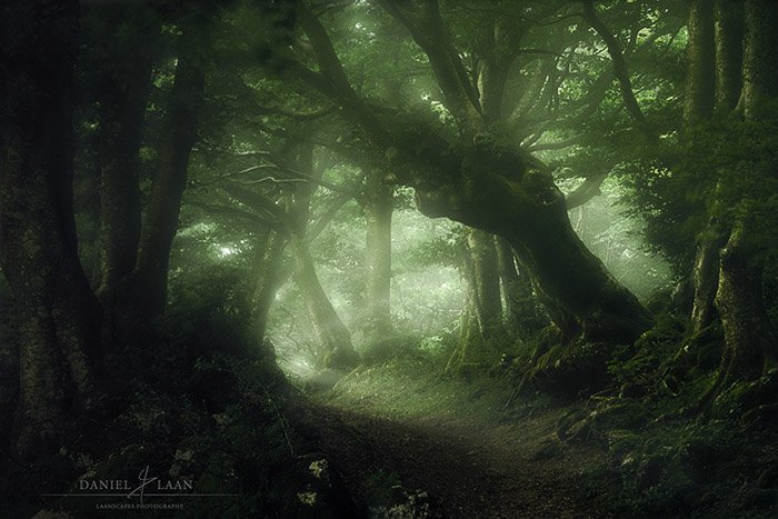
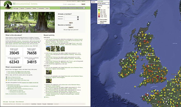
3. Best App for Finding Beautiful Trees: Monumental Trees
You can find everything online these days. Even the girth of trees around the globe. There’s this website with a huge database of the most stunning trees that are still around. It’s called MonumentalTrees.com.
At the time of writing, there are 35,045 trees documented.
These trees range from anything from a couple of meters to wood with over 30 meters in circumference. The website features an interactive map. This helps you explore the area digitally before heading out to the forest for some tree photography.
Beech trees and oaks are my personal favourites.
2. Best App for Seascapes: Tide Charts (Near Me)
Seascapes are as timeless as the sea itself. Although even the most empty, zen-like imagery contains some type of subject.
The best time for seascape photography, isn’t always sunrise or blue hour. It’s the about the time when the tide is receding.
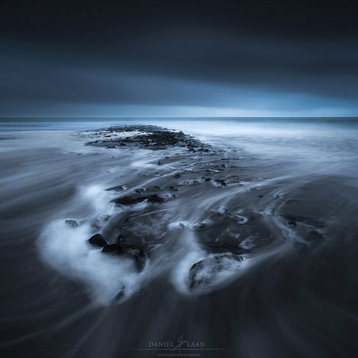
The receding tide has a number of benefits as opposed to high tide. Most importantly, footsteps are erased. Your rocky subjects in the sand will be adorned in nice foamy stretches. Especially with long exposure shots.
So when is the tide receding? Enter Tide Charts (Android) and Tide Charts Near Me (iOS). The apps are the same.
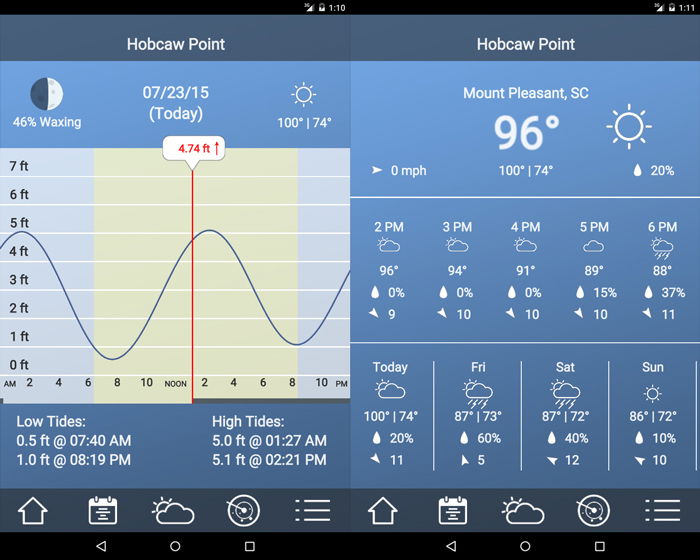
You’re looking for a moment when you’re at the edge of the water. Notice the point where the graph is coming down again. Tide Charts again works for any location in the world. This is handy if you’re a traveling photographer.
Also included is a small weather application. Use it it see if the weather’s clearing up, but don’t expect too much from this. There are better weather apps that we’ve discussed here.
1. Best Overall App for Landscape Photography: Google Earth
This one doesn’t need much introduction. Honestly, Google Earth is the first app that I used for landscape photography and I still use it today.
Plan your next shoot halfway across the planet with Google Earth. Virtually scout the area before you spend time, money and effort to discover that it isn’t worth it.
To me, Google Earth is just as good at eliminating locations as selecting them. So when you have limited time, you can make sure that it’s well spent.
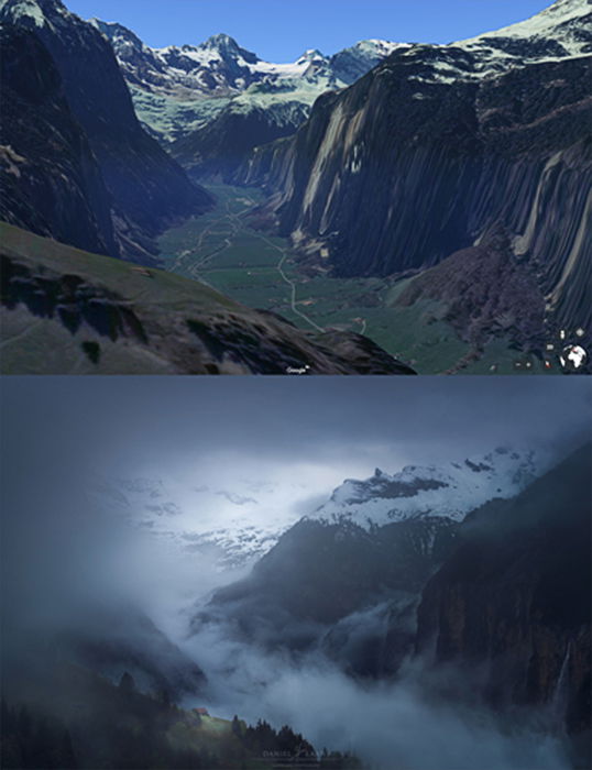
I use both Streetview and the built-in 3D functionalities. These give me an idea of my position relative to my surroundings. It helps to then know where the light will be fantastic at sunset or sunrise.
It has gone through some changes over the years, but now, within the Chrome browser, it is at its most nimble. Earth is fast, accurate and available anywhere for free. Definitely at the top of my list of best landscape apps for a long time.
Now check out our list of top editing apps for iPhone and Android users!
![]()
![]()
![]()
![]()